When French-Canadian fur trappers first surveyed the mountain range straddling the Idaho-Montana border, they dubbed it the Cabinet Mountains, for the shelves of rock that loomed over the rivers below. In the intervening 200 years, the hiking technology used to cross the Cabinets may have changed, but little else has.
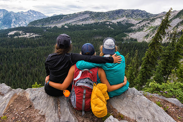
The Cabinet Mountains are commonly regarded as one of the wildest mountain ranges in the lower 48 states. Grizzly bears, mountain goats, and even wolverines take refuge among its glacier-carved cirques and hanging valleys. The Cabinet Mountains Wilderness protects almost 100,000 acres of alpine lakes and knife-edge peaks in the heart of the range. Think of it as an off-the-beaten-path alternative to Glacier National Park. These five day hikes or overnight backpack trips in the Cabinets are also an easy drive from Spokane or North Idaho.
Rock Lake
(7.8 miles)
A disused access road to a defunct mine offers easy access to this popular Cabinets destination, its many islets and coves occupying one of the most spectacular hanging valleys in the range, all under the sheer-faced spectacle of Ojibway Peak.
Getting There: From Montana Highway 200 about 1.8 miles east of the Noxon turnoff, and just past the railroad crossing (milepost 17.1), turn north onto Rock Creek Road (Forest Road 150). Drive 0.2 mile and bear right under the powerlines to stay on FR 150. Continue 5.8 miles to the junction of FR 150A, bearing right and continuing 1.6 miles on increasingly rough road to the trailhead (elev. 3270 feet).
Engle Lake
(6.4 miles / 2,900 feet elevation gain)
A high-elevation trailhead, a high subalpine lake, ridgetop walking through one of the best beargrass displays in the Cabinets, and the possibility to bag a peak sans scrambling make this hike a six-mile sampler of what the Cabinets have to offer. But make no mistake: even with a high-elevation trailhead, Engle Lake doesn’t skimp on the characteristic steep that other classic Cabinet Mountains hikes offer.
Getting There: From Montana Highway 200 about 1.8 miles east of the Noxon turnoff, and just past the railroad crossing (milepost 17.1), turn north onto Rock Creek Road (Forest Road 150). Drive 0.2 mile and bear right under the powerlines to stay on FR 150. Continue 4.5 miles and, just before the bridge, turn right onto Orr Creek Road (FR 2285). Drive this good gravel road 7.4 miles to the road’s end and trailhead (elev. 4,940 feet).
Cedar Lakes
(10 miles / 3,200 feet elevation gain)
If the Cabinets are a miniature version of Glacier, the hike to Cedar Lakes explains why: tumbling, tumultuous creeks; indigo subalpine lakes, and the amphitheater-like walls of glaciated peaks. The only thing missing is the crowds.
Getting There: From downtown Libby, Mont., drive west on US Highway 2 for 7 miles. Just after crossing Cedar Creek, turn left (south) onto Cedar Creek Road. Drive 2.5 miles to the road’s end and large trailhead parking lot (elev. 2,920 feet).
Leigh Lake
(2.8 miles / 1,910 feet elevation gain)
Short—albeit steep—access to the second-largest lake in the Cabinet Mountains Wilderness means Leigh Lake is a popular spot: some 3,000 people visit its sprawling shores every year. But the destination—a granite-ringed subalpine lake set under the highest peak in the Cabinets—makes up for the lack of elbow room. And a resident mountain goat herd means Leigh Lake is truly a “kid”-friendly hike!
Getting There: From Libby, drive 8 miles south on US Highway 2. Just past milepost 40, turn right on Bear Creek Road (Forest Road 278). Drive 3 miles, then turn right on Cherry Creek Road (FR 867). Drive 4.3 miles and turn right on Leigh Creek Road (FR 4786), negotiating 1.7 of rough, rocky, and slow miles to the road’s end and trailhead (elev. 4,090 feet).
Geiger Lakes
(5.8 miles / 1810 feet elevation gain)
Sheltered on a set of timbered shelves just below the sprawling subalpine lawns of the Cabinet Divide, this pair of pretty lakes gives high reward for your hiking effort. Add in an easy and essential side trip to Lost Buck Pass and its bedrock overlook of the interior of the Cabinet Mountains Wilderness, and you have a Cabinets classic. No surprise, then, that it’s quite popular; this is one of the few Cabinets trails where you’re likely to have frequent encounters with other hikers.
Getting There: From Libby, Mont., drive 24 miles southeast on US Highway 2. Shortly after milepost 56, turn right on West Fisher Creek Road (Forest Road 231). Drive 5.8 miles, then turn left on FR 2332. In 0.5 mile, turn left on FR 6748, cross the bridge, and continue for 1.6 occasionally rough miles to the road’s end and trailhead (elev. 3,750 feet). //
Aaron Theisen is a Spokane-based writer and photographer and author of the newly-released book “Day Hiking Glacier National Park and Western Montana.” He wrote about the region’s bike parks in the June issue of Out There.
[Feature photo: Aaron Theisen]
For more Montana hikes be sure to check out Katie LeBlanc’s article “Hiking Northwest Montana’s Backcountry.”