By Blair Libby
After admiring, camping alongside, and inundating myself in the Pacific Northwest Trail’s dozens of backcountry waters, I’ve devised my own rating system for the benefit of Out There Outdoors’ lake enthusiasts: The Way There, Big Rocks, Snackability, and Wildlife.
Ball Lakes and Pyramid Lake (Moderate)
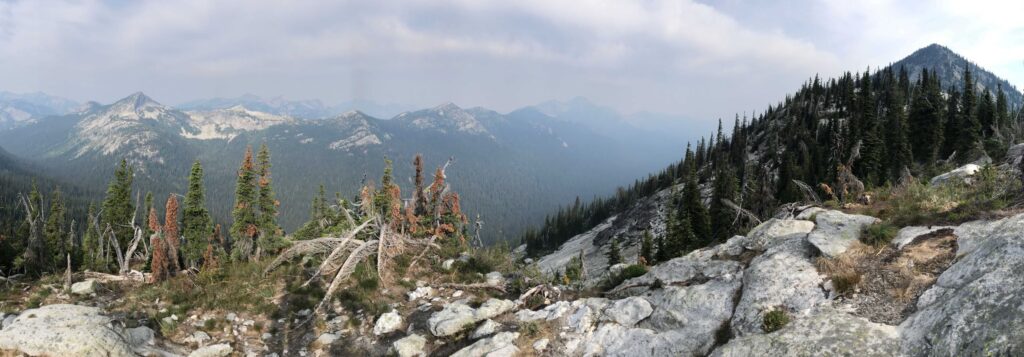
The Way There: These lakes are nestled high up in Idaho’s Panhandle National Forest. Luckily, they aren’t too difficult to access. From the Kootenai National Wildlife Refuge headquarters, you’ll drive a total of 20 miles on paved road, then gravel USFS roads. At the trailhead, follow Pyramid Lake Trail #43 for less than 1 mile to Pyramid Lake. Keep going on uneven, rocky switchbacks to reach Upper Ball Lake around the 2-mile mark. Lower Ball Lake is just a half mile further. 5 miles out-and-back with 1000 feet of elevation gain.
Big Rocks: Large granite faces rise to the west of all three lakes, with steep trail routed through scree fields. While on trail, enjoy views of the Selkirk Mountains’ high summits and deep canyons.
Snackability: Experienced hikers can reach Lower Ball in about an hour, so bring along your favorite lightweight refrigerated items, like fruits and cheeses. Apparently, there are fish, too, so bring your rod if you’re planning to camp.
Wildlife: A pair of bald eagles roosted at Upper Ball in 2018. Otherwise, bring your bear spray. The area is home to mountain lions, black bears, and occasionally grizzlies.

Bagley Lakes (Easy)
The Way There: Adjacent to Washington’s Mt. Baker Ski Area are several small alpine lakes. From Mount Baker Highway, park at Bagley Lakes Loop trailhead. This mostly flat and gentle 1.5-mile loop will take you around two lakes. Driving a few miles to the end of the highway, park at Artist Point for a half mile out-and-back to Huntoon Point, which on a clear day boasts astounding views of Mount Baker, Mount Shuksan,and Baker Lake.
Big Rocks: Mount Baker is one of the most prominent peaks in the Cascades and the second most active volcano, behind Mount Saint Helens. Table Mountain, the glacial peak to the immediate southeast of the trailheads, drains into Bagley Creek, which connects the two lakes.
Snackability: Enjoy the food at Heather Meadows Café or bring your own. Picnic tables and parking lots are plentiful.
Wildlife: Be on the lookout for mountain goats and elk.
Seven Lakes Basin (Difficult)
The Way There: After obtaining your Olympic National Park backcountry permit, from Highway 101, travel 12 miles up Sol Duc Hot Springs Road. Take Sol Duc Falls Trail to the waterfall, then Deer Lake Trail to the first densely wooded lake. Take the High Divide Trail another 3 miles to the Seven Lakes Basin Trail—you can’t miss the lakes. Continuing to Heart Lake will allow you to loop back on the Sol Duc River Trail, for a total of 19 miles and 4,000 feet of elevation gain.
Big Rocks: The High Divide Trail offers breathtaking views of Mount Olympus, the crown jewel of the park.
Snackability: If you’re day-tripping, carry some lightweight, high-calorie food, like bars or sandwiches. You’ll find plenty of water along the way, but remember to bring your filter.
Wildlife: You’re likely to see more than a few black bears in this area. Carry bear spray as a precaution, but they’re likely too preoccupied with summer berries to care about you at all. Olympic National Park is in the process of removing non-native mountain goats, which were introduced in the early 20th century for game hunting. If you see one, keep your distance.
Editor’s Note: For more information and directions to trailheads in Washington State, the Washington Trails Association website, www.wta.org, is a great resource.