I was sitting at my desk this summer, sipping ice cold Coronas, when something happened that made me realize what this winter could possibly bring. It rained in August. And not just a few sprinkles that evaporated the second they hit the ground, but a full-on downpour so strong it soaked the lawn, washed my car, and scared the bejesus out of the dog. Now for all of you refugees that have migrated to the east side of this great state of ours, that might not seem like a big deal. But take it from this sunburned, raccoon-eyed native of the Eastern Washington scablands when I say that rain in August usually means Old Man Winter is fixin’ to pay us a visit this year, and it looks like he might be bringing a half-full can of whoop-ass and his sister La Nina with him. The key word here is might, but I was so excited by this obvious sign from Ullr I went out to our storage shed and fingered my powder skis. Twice. Now before you get all worked up and go throw down the big bucks for some new fat sticks, have a look at what the weather gurus have to say about what lies in store for the Pacific Northwest this winter.
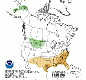
NOAA Climate Prediction Center
Remember that kid you sat next to in Meteorology 101 who seemed to get a little too excited during lectures about cumulous nimbus cloud formations? Yeah, he got his Ph.D. at age 22 and now works in a building with 500 people just like him, and they are projecting a “40% chance of La Nina developing in late fall and winter of 2016/17…with above average precipitation and below average temperatures in the Pacific Northwest from November 2016 to March 2017.” For those of you who don’t habla, La Nina is a weather condition that develops due to a cooling of the sub-surface temperatures in the Pacific Ocean and normally results in stormy weather in our neck of the woods and can produce epic, multi-day powder dumps. Think Snowmageddon in ’98 when people’s roofs collapsed and skiers actually died from having too much fun. Oh, and a 40% chance of La Nina is a heck of a lot better than nada.
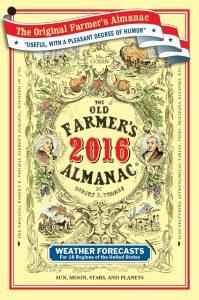
The Old Farmer’s Almanac
Not to be confused with those wankers over at the “New” Farmer’s Almanac. Founded in 1792, the OFA weather sages use a mixture of historic climate data, witchcraft, folklore, and Scientology (Tom Cruise is a huge skier) to develop their prognostications, and they do a damn fine job. Their crystal ball says we can expect “below normal temperatures, with the coldest periods being mid-late December and mid-late January, with the heaviest snowfall expected to hit in early December and mid-January.” I couldn’t see what was projected after that as I didn’t want to pay for an 18 month renewable subscription, and my editor wouldn’t throw down for it either. Oh, I was also kidding about the Scientology stuff. Sort of.
The Farmer’s Almanac
Not to be confused with those d-bags over at the “Old” Farmer’s Almanac. The folks at FA are not projecting this winter in the PNW to be as severe as some other groups are, but it’s sure good to have a voice of conservative reason in the mix, right? Methinks not. No sir, predicting a winter that consists of “above average precipitation and mild temperatures” will not suffice for your humble narrator, nor for you, dear reader. Thankfully, we benefit from a nice big cold air mass that typically parks itself over southern British Columbia and tends to seep down to us, so hopefully that above average precip will collide with it and provide some tasty powder dumps. You gotta think positive, bro.
AccuWeather
Always good to have one guy who keeps that growing excitement in check, and the forecasters at AW play the role perfectly. Although they are predicting a weak La Nina to develop during late fall and into the winter, “an area of warmer-than-normal water off of the northwest U.S. coast, nicknamed the “warm blob,” is inhibiting the development of a strong La Nina. Though the Pacific Northwest will shoulder the brunt of La Nina’s impacts that produce stormy conditions, the warm blob will limit the cold a typical La Nina would bring to the area.” Again, see reference to nice big cold air mass in southern B.C. in paragraph above. We’re good. Bring it.
Office of Washington State Climatologist
Anybody else think that it’s kinda odd that we even have a state climatologist? Actually, this being Washington state, I am surprised we don’t have 4 or them, with funding coming from some goofy toll on I90. But I digress. OWSC is basically parroting NOAA’s forecast for a decent chance of above average precip and below average temps, but with a special note for skiers and riders. “Although average temperatures will be lower throughout the state during the traditional snow sports season, skiers and riders visiting resorts located on or west of the Cascade Crest should continue to utilize black plastic garbage bags and ankle braces as the amount of moisture in both the air (rain) and the snow can lead to soggy clothing and the phenomena known as ‘Cascade Concrete.’ Conversely, those traveling to areas east of the Cascades should possess sunglasses and ample amounts of sunscreen, which will help in reducing the deepness of suntans and smile lines, both of which could draw the ire of one’s co-workers on Monday morning.” //