The importance of local indigenous place names
Land acknowledgements have been de rigueur the last few years, with many organizations and events acknowledging that they are on the traditional lands of the indigenous nations that had historically inhabited that land. The Native Governance Center suggests that one way to build upon a land acknowledgment is to investigate the indigenous history of the land, to learn the place names, locations, and landmarks of indigenous significance in the area.
This is where learning about Traditional Cultural Places (TCP) comes in, as these places had names millennia before you and I came along. Confederated Tribes of the Colville Reservation Chairman Jarred-Michael Erickson says that one reason for Out There Outdoors readers and others to learn and be aware of these names is that recognizing “the traditional names gives a better understanding of the people who came before us, where we are coming from as tribal people, and to foster an appreciation of the ways of our ancestors.”
TCPs can be religious areas, resource gathering areas (plant, animal, fish and mineral), places associated with stories and legends, archaeological and ethnographic sites, habitation sites, camp sites, rock images, trails, and more. In some respects, this definition covers pretty much the whole of the Inland Northwest, if not North America and the world.
These place names are not to be confused with such acts as renaming Fort George Wright Drive as Whistalks Way. This renaming honors Whistalks, wife of Yakama Chieftain Qualchan. These re-namings matter in a different way because they carry cultural and historical connections that might otherwise be lost despite not being connected to a specific site of indigenous significance.
Probably the most visited TCP site in the Inland Northwest is Riverfront Park and the area around the Spokane Falls itself, which was the largest fishing village in the area. Commemorating that history is the “Place of Truths Plaza,” where statues of indigenous figures can be viewed netting and spearing fish alongside metal figures representing Interior Salish creation myths. But there are many more.
Not only was the area around Riverfront Park a prime fishing location, Marsha Wynecoop of the Spokane Tribe says the area hosted a gathering of the people to not just harvest and cure salmon, but engage in stick games, story telling, dancing and other social activities. Within the park is the former Canada Island, snxw meneɂ, for Salmon People. In many respects, Riverfront Park has returned the area to its original use.
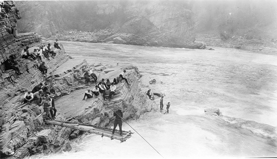
Many place names and their history are in danger of being lost due to anglicized naming, while some places have been uniquely inundated behind the waters of the Grand Coulee Dam. One such place is Kettle Falls—known to the Colville, in the English transition, as “Roaring Waters”—where the falls previously fell over 50 feet, ensuring that only the hardiest of fish made it farther upstream to spawn, strengthening the stock for future generations. This run was stopped by the construction of the Grand Coulee Dam. One legend behind Kettle Falls has Coyote bringing Salmon up the Columbia River, creating a diversion to help the fish break the blockade created in the Dalles by Seagull, Kingfish and Snipe. In the process, Coyote also created Okanagan Falls from a pile of salmon bones.
One place that has not been inundated is Palouse Falls, pelúuc. There are two legends behind the creation of the falls. One legend is that four giant brothers had run out of beaver oil, and in attempting to get more, as they fought with beaver, he thrashed about, creating the canyon walls, causing the river to bend and change. The other is that beaver was making a canyon and those living in the area wanted to stop him from doing so. A warrior went to kill beaver, and in the fighting, the canyons and falls were created.
These generally available place names and legends are not even the tip of the iceberg concerning the original names of the places we live in and enjoy in the Inland Northwest. The traditional lands of the Colville Confederation cover 39 million acres that stretched from Eastern Oregon to British Columbia. That range has been reduced to 1.4 million acres of the present reservation. There are mountains, mountain ranges, and so much more not included in current records.
One goal Chairman Erickson has is to get the Washington State Department of Transportation to put indigenous place names on road signs, an effort he hopes will soon be underway. This can help foster awareness of the history of the first people of the region, reestablishing the indigenous legacy and the long-established history of the land. “Place names are important because they show evidence that we have been here since time immemorial, that we have a connection to the place and what is in our history,” says Erickson.
Learning place names, the stories behind them, and bringing those names into current signage is a respectful first step to truly acknowledging the land upon which we live and play. //
Bradley Bleck loves digging into the history of the Inland Northwest. He last wrote about Soap Lake and its healing waters for the July/August issue of OTO.