By Paul Delaney
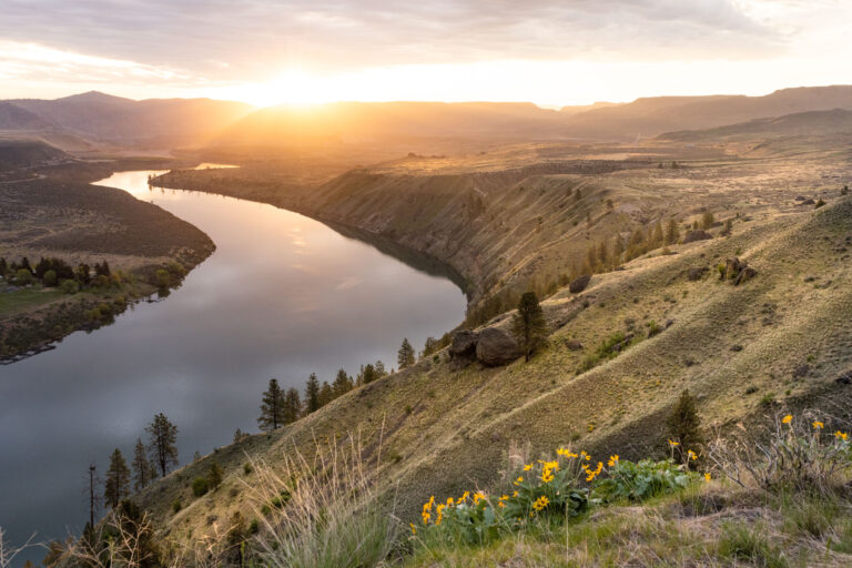
For those who wonder what the pioneers might have seen as they traveled the Oregon Trail in the 1840s, take a trip to the Owyhee River in faraway southeastern Oregon.
And while you’re at it, since you likely drove hundreds of miles, better take the next five days and experience the 50 miles of Owyhee from “see level.” Because why else, other than maybe taking U.S. 95, the scenic “Blue Highway” route to Reno, Tahoe, and maybe Las Vegas, would you venture into the visage of the middle of nowhere?
That opportunity came my way in the spring of 2019 when I was able to knock the Owyhee off of a river bucket list that officially turned 40 this year.

But much has to fall into place to experience this river that defines the word “remote.” The Owyhee flows through vast Malheur County with just 3.2 people per each of its nearly 10,000 square miles. By comparison Spokane County has 275 people for each of its 1,800 square miles.
Enveloping the Owyhee canyon is one of the largest undeveloped tracts of public land left in the lower 48 states—and it shows, particularly on the drive out from Birch Creek.
The ability to raft the Owyhee and its handful of notable rapids—Whistling Bird, Montgomery, and Rock Dam—requires the fickle weather of the high desert to cooperate.
Tales of freezing temperatures and winter/spring rafting encased in a drysuit, plus the pure logistics, always had the Owyhee on my list. But retirement opened plenty of options, and our group won with temperatures in the 70s and just a sprinkle of rain after a May 5 launch.
The best Owyhee opportunities happen when the West’s winter is influenced by an El Niño where the storm track generally dives south into California. Officially, the winter of 2018-19 was “neutral”—neither El Niño or La Niña— same as 2019-20.

Our trip ran from the Bureau of Land Management boat ramp and campground, just east of the wide spot in U.S. Highway 95 known as Rome, and covered 50 miles to the remote Birch Creek Ranch takeout. Add 10 miles of flat water, with a motor heavily advised, if you take out at Leslie Gulch.
Upstream from Rome is the dynamic but incredibly difficult middle section of the Owyhee. This 35-mile stretch from remote Three Forks includes Half-Mile and Bombshelter, a pair of Class-4 drops, and arguably the darkest name for a rapid ever—Widowmaker. It’s a Class VI falls that does get run, but is normally portaged. Google it and either option ought to make you cringe.
The entire Owyhee is full of both geologic and pioneer history.
From Rome there are still scattered remnants of pioneer homesteads. Jean-Baptiste Charbonneau, the son of Sacajawea is buried in the area. The rusted relic of a waterwheel sits along the shore near Birch Creek.
The Owyhee River and its tributaries flow through the Owyhee Plateau, cutting deep canyons, often with vertical walls and in some places over 1,000 feet deep. Its headwaters are in northern Nevada and the river is 280 miles long. Notable among the many stunning vistas are Lambert Dome in the Chalk Basin—composed of layers of reddish rhyolite and basalt—and Iron Point Canyon with its towering sheer walls.
Lower Owyhee River Trip Details
- Rome to Birch Creek or Leslie Gulch Length: 48 or 65 miles
- Gradient: 15 fpm
- Difficulty: Class III
- Season: Spring
- Rec. Level: 800 – 5,000 cfs
- Agency: BLM
- Permits: Self Registration
- Put-in: Rome
- Take-out: Birch Creek or Leslie Gulch
- More info: www.whitewaterguidebook.com
Originally published as “Owyhee: A River for the Bucket List” in the June 2020 issue.

Paul Delaney has been a whitewater enthusiast since 1980 and has rafted dozens of rivers across the west. He’s a co-founder of the Northwest Whitewater Association Rafting Club and can be reached at [email protected].


