It was late fall in North Cascades National Park, and snow was already coating the high peaks. But on this particular day, the sun was shining. Temperatures were climbing into the 50s. Best of all, the hordes of summer backpackers who flock to the alpine glory of Copper Ridge were gone.

The weather forecast called for bad weather later in the evening—rain in the valley, snow in the mountains. But I was eager to run the 36-mile Copper Ridge Loop, a classic North Cascades backpacking route that most people hike over several days. This was possibly my last chance of the season. I checked the forecast, predicted the time it would take given my pace, and decided I had enough time to make it work.
The first miles clipped by. After an hour and 4 miles of running, I was atop Hannegan Pass, the site of an unregulated first-come first-served Forest Service campground. In another mile I passed into North Cascades National Park, and turned left at the junction to ascend Copper Ridge.
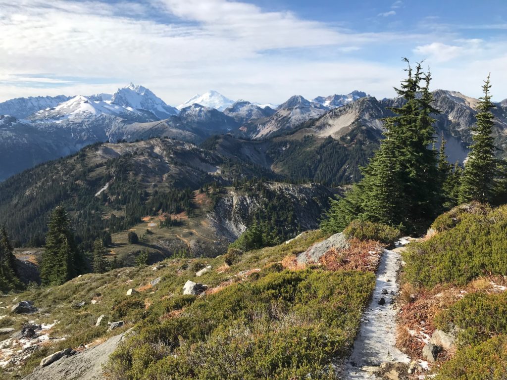
I climbed, rising steadily above the trees. From the ridge, I had a 360-degree view of the glacier-carved peaks of the Cascades—Indian Mountain to the east, Hannegan Peak to the west, and the jagged, vertigo-inducing spires of the Pickett Range further to the south. Green forests from the valleys blended into oranges, reds, and yellows up high, where the trees gave way to the fall colors of alpine vegetation—willows, huckleberries, and heather. Above 6000 feet, everything was covered in a thin, frosty film of white.
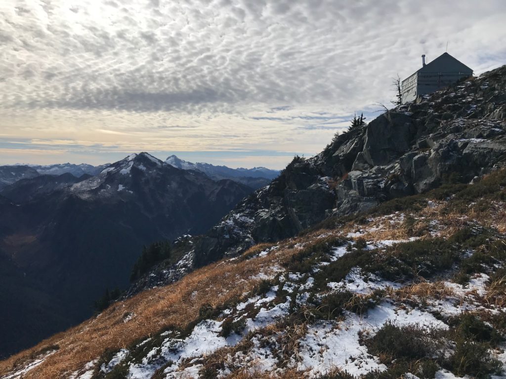
Atop the ridge I met another runner going the other way, returning from an out-and-back run to the Copper Ridge Lookout.
“Just taking advantage of the good weather while it lasts!” I said as we crossed paths.
“Hey man, this is it! Last day of the year!” he called back exuberantly.
I passed two backcountry campsites (reserveable in person at one of the park offices) on the ridge before reaching the now-unstaffed lookout cabin at mile 10.
Now I could see down the Chilliwack River, far into Canada. Jagged mountain peaks surrounded me in all directions. I wanted to linger, but a chilly breeze pushed me onward. I was wearing only a long-sleeved t-shirt and a thin pair of running shorts, so I relied on movement to keep me warm.
My running shoes crunched through crispy patches of snow as I picked my way along the ridge. At 11.4 miles the trail passed Copper Lake, the last campsite on the ridge. As I skirted the east flank of 7142-foot Copper Mountain, I soaked up one last alpine vista before descending 3000 feet to the valley below.
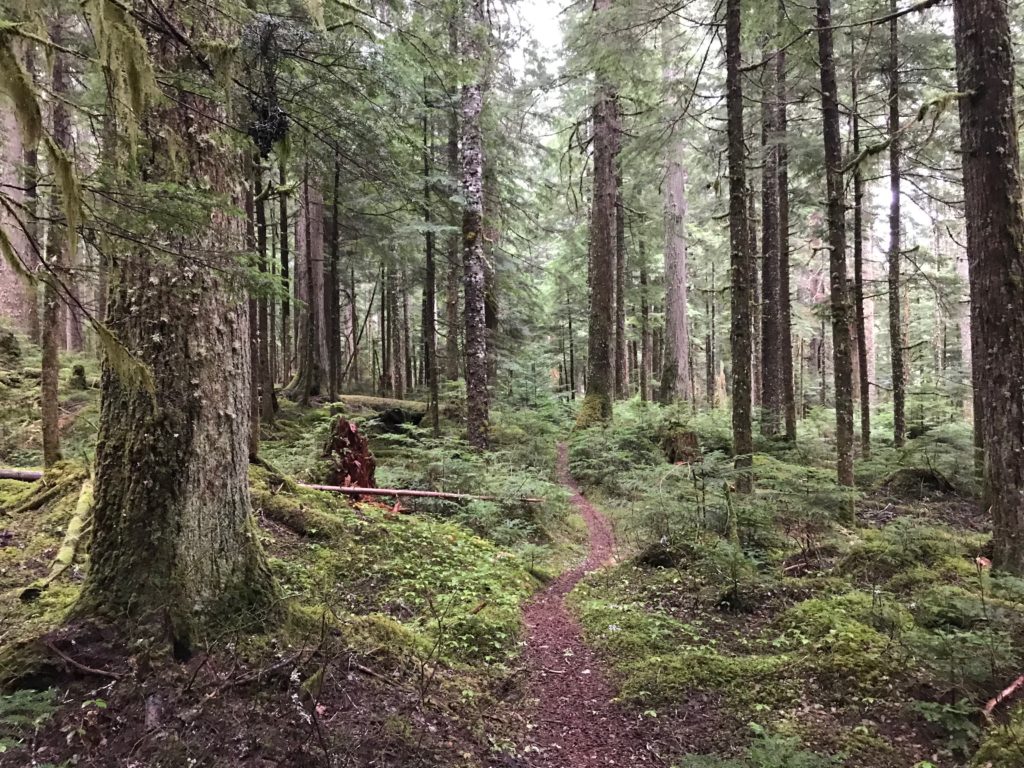
It felt like a different world. I had left the wind-scoured tundra, where hundred-year-old trees might be four feet tall, and entered the land of giants. Old growth firs and cedars, many five feet or more in diameter, stood sentry over the bottomlands. Centuries of fallen timber and rock lay beneath a shaggy carpet of emerald-colored moss.
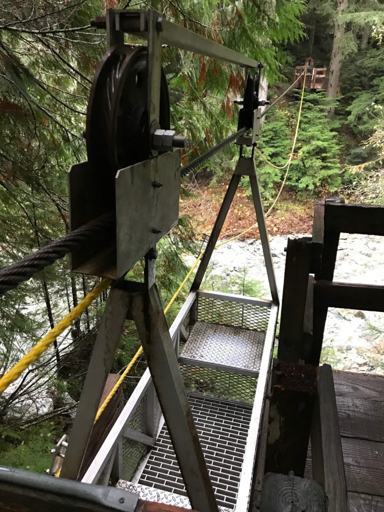
I forded the river and began the slow ascent back to Hannegan Pass. Near the 24-mile mark, I crossed the Chilliwack on an aerial tramway, pulling myself across the river in a cable car.
Now I was getting tired. The sun was sinking low, and the temperature was dropping. The trail steepened. As I clicked on my headlamp, my pace slowed to a walk.
That’s when the first raindrops began to fall. It started as a light drizzle but soon became a drenching rain. Clearly, I had not beaten the weather.
As I climbed the pass, the rain turned to snow, blowing horizontally in the stiff wind. By the time I crested the pass, I was thoroughly soaked. My hands and ears were numb. I had only four downhill miles to go, but after running 32 miles and ascending nearly 10,000 feet, the task seemed Herculean.
I checked the campsite for backpackers who might be able to help me out, but finding no one I took refuge in the outhouse.
I considered spending the night there. It was sheltered, and I could continue in the morning.
But the temperature was already well below freezing, and I was wet. If a lot of snow fell overnight the trail could become difficult.
I pushed on, summoning my reserves to run the final miles. I moved quickly, aware that I was losing body heat. But I was also wary of injuring myself on the slippery rocks.
It was nearly 9 p.m. before I reached the trailhead. Coincidentally, a pair of climbers were also returning, chatting away as their ice axes clanked against their crampons in the darkness. I tried to call out and let them know I was there, but my voice didn’t carry in the wind and rain.
As I neared one of them, she let out a scream, nearly toppling over with surprise. I mumbled an apology before pushing past the couple to my car.The trail was one of the most visually stunning I’ve ever seen. But next time I think I’ll give myself a few more hours.
Backpacking the Copper Ridge Loop
The Copper Ridge Loop in the North Cascades is a classic backpacking route with epic climbs (over 8,000 feet of elevation gain), mountain lakes and streams, stellar alpine scenery, and even a self-propelled cable car river crossing. The loop can be hiked as a multi-day backpacking trip over several days, or, if you’re short on time or enjoy a good sufferfest, hiked or ran in one long day.
Round-trip distance:36 miles
Season:July-October
Rating:Difficult
Permits:A backcountry permit, available at a National Park office no more than 24 hours in advance, is required for overnight camping in North Cascades National Park. A Northwest Forest Pass is also necessary for trailhead parking. in person at a National Park office no more than 24 hours in advance.