A 530-Mile Journey Through Northeast Oregon’s Wildest Terrain
By Olivia Dugenet
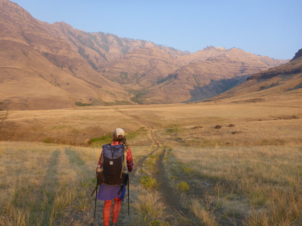
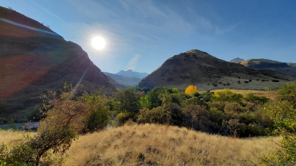
Cover photo courtesy of Renee Patrick
From where they stood up on the rim, the three hikers tried to follow the route down into the deep and wild Joseph Canyon toward the Imnaha River. The map suggested there should be a trail. The ground told a different story.
The path disappeared into a sea of open, untracked terrain. The hikers followed some cows, hoping they would lead the way to the water. But the cows stopped to relax and graze, keeping their secret paths to themselves and leaving the trio in a bind.
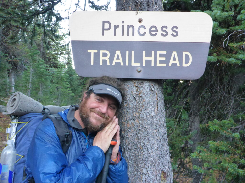
“We walked into a wall of blackberries so high and thick we couldn’t get through,” says Whitney “Allgood” LaRuffa, one of the first to thru-hike the new Blue Mountains Trail in Northeast Oregon.
It took them 90 minutes to move 300 horizontal feet through the tangle of thorns that evening. They had to give up for the night and bivouac on a small outcropping. The next morning, after spending hours scouting a way down into the canyon, they discovered that the trails they expected to find at the bottom had been reclaimed by blackberry and poison ivy. With no way through the dense growth, they walked 9.5 miles in the water. The riverbed was the only viable path toward the next section of trail. With the hard-won humor of a person accustomed to extended periods of suffering in the outdoors, LaRuffa unleashed a big smile and said, “Yeah, we had a pretty rough go.”
LaRuffa’s group tracked every lost trail, dried-up water source and waypoint from start to finish during that first ground-truthing trip in September 2020. They fed that information to Renee “She-ra” Patrick, who was the first to solo-hike the Blue Mountains Trail (BMT) a month later. Patrick experimented with alternate routes that bypassed the problems LaRuffa’s group had encountered. These original expeditions helped make the trail what it is today. While Jared Kennedy of the Greater Hells Canyon Council (GHCC) spent more than 400 hours compiling data from maps and other sources, researching, planning and stitching existing trails and Forest Service roads into a single cohesive route, ground truthers tested that data by walking the trail and observing what was actually there. Thanks to their feedback, the revised trail now bypasses the traps that made that first run such an ordeal.
THE INCREDIBLE BLUE MOUNTAINS TERRAIN
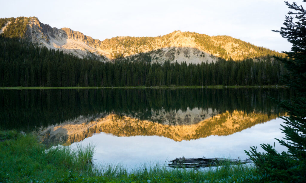
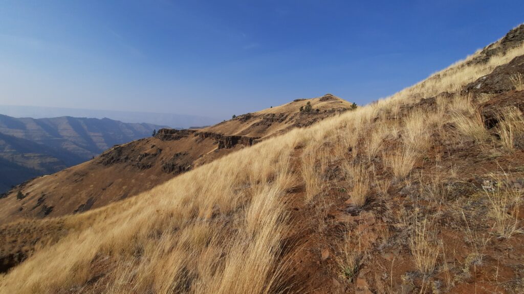
In its current form, the 530-mile Blue Mountains Trail spirals through Northeast Oregon, from Joseph to John Day. Depending on preference, time available and skill level, people use the trail for day hiking, section hikes that range from a few days to a couple of weeks or a monthlong thru-hike of the whole thing. The route traverses rich and variable terrain, including an alpine region that looks like the Swiss Alps (the Wallowas), the deepest canyon in North America—yes, Hells Canyon is deeper than the Grand Canyon—the last fully intact prairie in the American West (Zumwalt) and a world-famous 30,000-ton subterranean fungal organism (Clear Creek Honey Mushroom) that covers 4 square miles and has been quietly thriving in the same place for at least 2,000 years.
Not many witness these wonders. People commonly bypass Eastern Oregon completely, thinking of it as a desertlike extension of the Great Basin. “Northeast Oregon is misunderstood,” says Kennedy. While it does contain high desert landscapes, especially in the canyons, it also holds old-growth trees dripping with moss. “You’ve got so much more moisture in the Blues because of the way it’s funneled through the Columbia River Gorge and pulled into this mountain region,” he says. “It’s this huge, green, conifer forest. I mean, it’s so different from what people think it is.”
While it may seem like keeping the region a secret is the best way to protect it, Kennedy says he and GHCC firmly believe that “people will protect what they love. When we talk about our effort to protect the last 3% of old-growth trees that exist—these massive giants of ponderosa pine—well, it’s hard to do so when people don’t think that there are any trees out there.”
In an area like the Blues, where extractive practices like logging and mining heavily impact landscapes, increased awareness and more recreation will help conservation groups like GHCC achieve balance between conservation and industry, especially with recent cuts to federal grant funding for trail maintenance and other work.
A LONG TIME COMING
The idea to create what Kennedy calls “a maintained trail backbone through the entire Blues” is not new. He first learned about the effort in 2009, when an article in The Oregonian announced that an 870-mile “Blue Mountains Heritage Trail,” set to open the following year, would bring European-style hut-to-hut hiking to Northeast Oregon.
The ambitious Heritage Trail project was piloted by Loren Hughes, conservationist, jeweler and former director of the Greater Hells Canyon Preservation Council (now GHCC). Hughes first dreamed of creating a long-distance trail during a horse-packing trip through the Blues in 1960. He teamed up with retired schoolteacher and experienced backcountry traveler Dick Hentze, who worked on route building, and Mike Higgins, an outdoor enthusiast heavily involved in regional conservation efforts. Together they worked for decades to shape their idea and bring it to life.
The Oregonian story framed the original Heritage Trail primarily as an economic development venture meant to bring jobs and revenue to small communities. The plan was to attract European and Asian tourists interested in real cowboys, gold mining and ranching culture. Sadly, due to tragedy in Hentze’s life, the project lost momentum and became fully dormant when Hughes died several years later.
Kennedy was disappointed when that original project didn’t launch. He had dedicated years of personal and professional energy to supporting outdoor recreation in his home region. Kennedy was one of three founders—and later CEO—of Outdoor Project, a digital guide to human-powered outdoor recreation. In addition to leading the company, he regularly contributed content focused on hiking and backpacking in the Blue Mountain region. “I am drawn to places like Northeast Oregon where you have expansive landscapes, few people and abundant wildlife,” Kennedy says.
In 2019, when Outdoor Project sold its platform to OnXMaps, Kennedy began volunteering to revive BMT development. That volunteer project evolved into a permanent position as development director and BMT project leader with GHCC. From the start, he committed to creating “a place-based experience” that would weave deep connections between hikers, trail towns and the land itself.
The Blue Mountains Trail opened officially in 2021, a year after the ground-truthing journeys. GHCC is always learning, adjusting and improving the trail experience based on changing conditions and hiker feedback, Kennedy says, “so today’s route deviates somewhat from the route we launched in 2021, but it generally follows the same trails and is routed through the same towns.”
Kennedy and GHCC continue to prioritize the trail’s potential to benefit rural economies. However, rather than constructing a complex business concept and applying it to a landscape, Kennedy’s approach allows for a more organic, ground-up model that makes room for land and communities to speak for themselves.
CONNECTING COMMUNITY AND WILDERNESS
When rural economies and conservation priorities work in harmony, towns protect the land so the land can continue supporting the towns. That land draws hikers who appreciate and care for it. Hikers support businesses, which provide supplies and services to hikers. It’s a balanced approach.
“We really wanted to make sure the trail came right through towns,” Kennedy says, “both to make it easier for thru-hikers to resupply but also because so many trail towns in Northeast Oregon are so rural and really benefit from that connection to outdoor recreation.”
The trail connects the communities of Joseph, Troy, Tollgate, La Grande, Sumpter, Austin Junction and John Day. The BMT is still new enough that trail communities are not yet seeing major impacts associated with the route. Only 5 to 10 people attempt the full thru-hike in a year and not all of them finish.
When Patrick passed through trail towns, she approached with curiosity. She points out that some of these communities are incredibly small. Troy, for instance, is an unincorporated, village-like vacation community that doesn’t even have a post office. Some sources estimate its population at 25 permanent residents. There’s one store in town. “Just having a conversation with the store owner was so great. I sent him a postcard after the fact saying, ‘I finished! Thanks for your help. It was great to meet you.’ Now, five years later, a friend sent me a picture from the Troy store. The postcard is still there on the store’s bulletin board.”
Aside from the somewhat crowded trails of the Wallowas, the Blue Mountains have remained largely hidden from the masses. Far from population centers and tucked away from major highways, this region has quietly maintained not just wild beauty and deep solitude but also a fragile connectivity corridor that unites the westernmost arm of the Yellowstone ecoregion with the Cascades all the way to the Siskiyous in California.
Connectivity corridors are wild spaces that link habitats together, allowing wildlife to move freely across landscapes. The Blues are especially important in this regard because, as Kennedy explains, “you also have this really vast elevational gradient across the whole thing and that offers incredible niches for wildlife, flora and fauna both, to move around in a changing climate to find a way to maintain themselves.”
“You have extensive whitebark pine forests through the Blues that are a threatened species and pivotal for so much wildlife. And then you have this deep human history of Indigenous use of the land and these Indigenous communities,” he says, “that are such a powerful living part of the place.”
THRU-HIKING THE BMT
While this region is unique in its beauty and diversity, the hike itself is a challenge. LaRuffa, Patrick and Kennedy all agree that the BMT should not be a beginner’s first attempt at a thru-hike. There is a narrow weather window during which the BMT is safe to travel. In early summer, the high mountain passes are covered in snow. By late summer, the canyons are too hot to travel. September is the best month to try it.
Hikers without navigation experience may struggle to connect between sections. “There also might be long stretches without water,” Patrick says. “You really have to trust yourself and your skills,” which should include understanding how to read a topo map and use a compass.
For those not ready to take on the full BMT, a shorter section hike is a safe and beautiful way to start getting acquainted with this unique route. (Check out this article’s sidebar for a starting list.) The North Fork John Day Wilderness Area, for example, is seldom traveled and worth seeing. “I personally love the hike along the North Fork John Day River,” Kennedy says, noting that while there are only a few well-established backcountry campsites along this route, “there are few people and it’s a beautiful river canyon.”
Kennedy encourages people to work with GHCC when planning a hike along any section of the BMT, especially a multiday trip. GHCC maintains a comprehensive databook, available on its website, which provides logistics data corresponding to every waypoint on the map. Kennedy also provides a detailed range of digital and analog maps and tools.
“THIS IS AWESOME”
During the first ground-truthing trip, Kennedy remembers eagerly checking in by phone when LaRuffa and his companions reached the halfway mark in La Grande. Kennedy asked how it was going. LaRuffa described the first section as “awful” and the next section as “even worse!”
Kennedy asked hopefully, “And it got better after that?” LaRuffa said, “Oh, no. Then we did the Wenaha River Trail and that was the worst of all of them.”
“Are you guys even OK?” Kennedy asked. He recalls that their hike coincided with the Labor Day wildfires that created a major smoke event that year. “They were on the trail during that entire time. They had just a crazy experience. I talked to him again after he had gotten medical treatment for his poison ivy. I said, ‘So are you guys bailing?’ He said, ‘What? No, no, no. This is awesome, man.’”
LaRuffa says, “There was no way I was gonna not keep going…to me, that’s kind of where the excitement is. It’s in the unknown and the toughness. There’s joy in it. There are not many places left where you can actually have a real adventure.”
GHCC is eager to connect adventurous souls with the Blue Mountains Trail. For information, go to hellscanyon.org.
Olivia Dugenet is a Spokane-based writer and frequent backcountry traveler who will definitely spend time exploring the Northeast Oregon backcountry this year.