Autumn is the season best savored perhaps by creative writers, bird watchers and carefree nature lovers. Nineteenth-century writer William Cullen Bryant referred to this season as “the year’s last, loveliest smile,” and novelist Albert Camus said, “Autumn is a second spring where every leaf is a flower.”
Crisp mornings with frost, clothed in layers for shortened afternoons, and the cultural rituals of the season – including TV football – can help one feel content but also restless after a long, busy summer of outdoor activity.
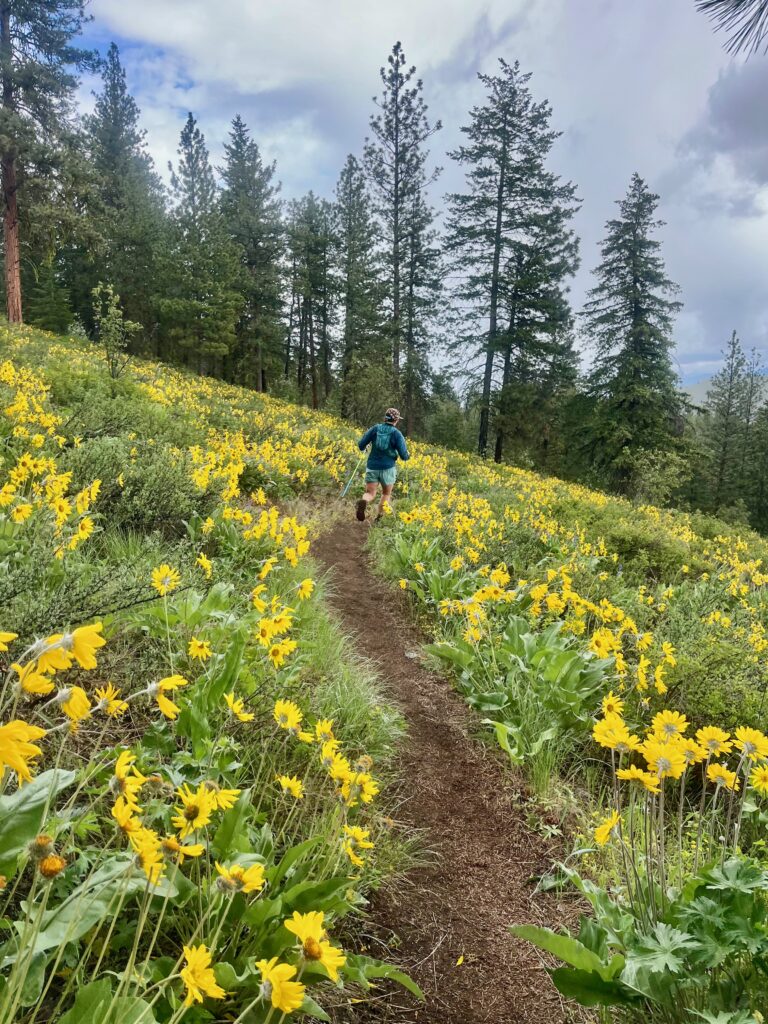
So take a hike – an easy way to enjoy this distinguished season and relish our four-season climate in the Inland Northwest. Familiar trails that were lush, green and punctuated with wildflowers in July take on a new identity by October. Deciduous trees and brush are changing into shades of yellow, red and brown. Fewer leaves allow more daylight on the path to notice small or new changes – like more insects, earthworms and hoof marks.
Here are three hiking destinations that provide autumn visual appeal along the trails.
Iller Creek Conservation Area – Spokane County
Closest to the Spokane metro region is the Iller Creek Conservation Area, which “consists of approximately 876 acres within the wildlife corridor linking Turnbull National Wildlife Refuge with the forests of the Dishman Hills Natural Area,” according to Spokane County’s website. Five different land acquisitions over the years, through the county’s Conservation Futures program, have provided this area for public recreation use.
Fifteen mammals, 86 bird species and other wildlife consider this valley and riparian corridor a haven. As of mid-September, the creek was dry, but the foliage was lush, mossy in places and the shrubs already showing their autumn color array.
Much of the trail is steep, and deep ruts from water and former use by off-road vehicles make it a rugged and somewhat difficult terrain. (Trekking poles are recommended.) Trail maintenance by volunteers occurred this past spring, and future trail work is planned.
According to the area map, there is a long loop – estimated to take three hours – and a short loop. (Specific mileage is not indicated on the trailhead signage.) From the sparse parking area off Holman Road (see “When You Go”) and trailhead, there is also the up-and-back hike option, which culminates in a spectacular and expansive view of the Palouse with Steptoe Butte in the distance. Peek-a-boo views of Spokane Valley through the trees are seen on the opposing side. Be aware that although motorbike riding is not one of the permissible uses, on the day I visited there were riders ripping their way up the trail to the ridge.
Still, this can be a family-friendly and “suitable for most abilities” type of trail. Starting from the entrance, follow the creek (there will be two creek crossings when there is water present) and take a right at the first trail junction. There are narrow, approximately four-foot high signs that help you differentiate what is the official trail and what is not, since some are closed until additional maintenance is completed.
At this first junction with a wide, nearly road-width trail, you can head left for views of the Spokane Valley, which will be visible to the right. Tower Mountain can be viewed to the left, across the valley.
But if you turn right at the junction and trek higher, you will pass a few Indian Paintbrush flowers (if still flowering) and an abandoned blue pick-up truck, off the trail to the right, before reaching the ridgeline. Here, turn right and continue on to the massive basalt rock formations to enjoy the views.
Close to the city and more frequently used, especially on nice-weather weekends, the trails of Iller Creek provide both physical and mental appeal.
Hub Lake In The Lolo National Forest – Western Montana
If you are willing to spend more time driving, a worthwhile destination to enjoy alpine wilderness and fall colors is Hub Lake in the Lolo National Forest backcountry. The six-mile round trip trail in the Bitterroot Mountain range offers views of Western larch trees, whose clustered needles turn golden yellow in the autumn before falling to the ground in November. While commonly referred to as Tamaracks, the Western larch is the most prolific in the Northern Rocky ecosystem, whereas the growing region for the Tamarack (the American larch) does not extend south of the Canadian border until Minnesota and farther east, according to the Peterson Field Guide to Western Trees. No matter what locals call them, the gold burst of color in a mountainside of evergreen is beautiful.
My husband and I first discovered this trail during the month of October, and it’s a good choice for a fall backpacking trip – especially on a sunny weekend. But dress for winter weather since the 5,700+ elevation level there will be freezing temperatures overnight.
At the trailhead located not far from I-90 near DeBorgia, Montana, take Trail 262 along Ward Creek. Old growth cedars, which survived the Great Fire of 1910, can be seen along the way. You will also pass Dipper Falls. Enjoy this 60-foot cascade while taking pictures and perhaps eating a snack.
After 1.25 miles, you will reach the junction with Hazel-Hub Lake Trail 280. With a backpack, the gradual switchbacks may feel tough, since there is 1,700 feet of total elevation gain. But take time to turn around and enjoy the vista. Snow-capped peaks of the Cabinet Mountains in the far distance and golden larch trees make the exertion worthwhile.
There is a junction for the short trail that drops down to Hazel Lake, which is discussed in 100 Hikes in the Inland Northwest by Rich Landers, but the shoreline is said to be brushy so it’s better to continue hiking until you reach Hub Lake.
Landers recommends early-October as the end of hiking season in this area, but Craig Romano, author of Best Hikes with Dogs in the Inland Northwest, characterizes the best hiking time as lasting “through mid-October.” It all depends on the weather. Check the forecast, pack the ten essentials for the backcountry, and be sure your extra clothing includes hat, gloves, long underwear and fleece.
You will trek through a meadow that features Ward and Eagle Peaks on its sides, before reaching the lake’s outlet. While there are camping places in this area, I recommend heading to the upper end of the lake where it’s flatter and out of the shade.
At this end of the lake, which is in a semi-open bowl, gaze to the ridge above to view stunning swaths of red-orange foliage. There is a lightly used and steep trail that leads up to the saddle of Ward and Eagle Peaks, known as Up Up Ridge with a trail by the same name – elevation 6,650 feet. Even if you don’t reach the ridge, I recommend going at least halfway up if it’s a clear day to look across the Bitterroot range. The next ridge of trees will be ablaze in gold and the far-off snowy peaks rise from the horizon, reminding you that winter is just around the corner.
Last time I visited Hub Lake during the month of October, the lake froze overnight, as did the water in my Nalgene bottle that was inside my tent. Our tent was also encrusted in a layer of frost. Even the sun of the next day was not enough to thaw the lake’s crust. But when you’re wearing fleece and layers, it doesn’t matter too much. To check current conditions, including weather and travel restrictions, go online to www.fs.fed.us/rl/lolo/conditions.
Sullivan Lake In The Colville National Forest – Northeast Washington
Located within Colville National Forest, about 95 miles north of Spokane near Metaline Falls, Sullivan Lake (2,600’ elevation) features a 4.1-mile trail along its eastern shore (mileage is for one-way). Known technically as Lakeshore Trail 504, its full, more prestigious name is the Lakeshore National Recreation Trail, and it’s also considered a North Pend Oreille Scenic Byway. This trail connects Sullivan Lake Campground on the north end of the lake with Noisy Creek Campground on the south. It allows you to enjoy fall colors concurrently with water views. It’s considered an easy trail, and although the grade is fairly level, sturdy shoes are recommended since you will cross some rockslides.
Although the campground closes in early September, this area can still be enjoyed as a day trip. According to Recreation.gov, a one-stop portal for recreation use on public lands, bears and cougars frequently visit this area. Use caution and avoid packing really odiferous food items, like a tuna fish sandwich.
If you’re feeling particularly ambitious, the Noisy Creek Trail, accessible from the campground by the same name, leads up 2,900 feet to Hall Mountain—the 39th highest peak in Washington State. Be on the lookout here for bighorn sheep and black bears. Before you go, check the National Weather Service forecast for this area. You can inquire about other conditions by calling the Sullivan Lake Ranger District office, (509) 446-7500.
As always, don’t venture out without essential items, even for a short day hike. Take along a first-aid kid, sun-protection, extra clothing, raingear, extra food and water, flashlight, and even a map and compass if you’ll be in less familiar territory—and especially when you’re going to the backcountry.
Go now—before Halloween, before the red leaves and the first snowflakes fall to the ground. And explore our local forests during their crusty yet beautiful finale of the year.
When You Go: Fall Hikes
ILLER CREEK CONSERVATION AREA: From Dishman-Mica Road, turn right at Schafer Road, right on 44th Avenue, then left on Woodruff Road (or Farr Road, but there is currently construction that discourages thru traffic). Turn right on Holman Road and drive 0.75 miles to a gentle switchback, where you’ll spot the entrance to the Conservation Area.
(You can’t continue on the road, as it turns into private property with prominent “Do Not Enter” signs.) Park on the right side of the road. There are garbage cans and a portable toilet at
the entrance.
HUB LAKE: On I-90, drive 7.5 miles east of DeBorgia, Montana, and take exit 26. Go south on Ward Creek Road 889 for about 6.5 miles, and the trailhead will be on the right side of the road just before crossing Ward Creek.
SULLIVAN LAKE: Take Highway 31 north through Metaline Falls. One mile north of the town, turn onto County Road 9345. Go 6.5 miles to the junction with Forest Road 22, turn and proceed a short distance to the Sullivan Lake Campground. Noisy Creek Campground is accessible from the same county road; trailhead is located at the boat launch parking area.