Joseph, Oregon
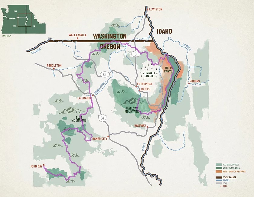
The Blue Mountains Trail, a work in progress for decades, has evolved into a 566-mile point-to-point long-distance trail with a spiral shape connecting its two ends, Wallowa Lake State Park near Joseph and John Day.
Like most thru-hikes, this one is still a work in progress. The trail traverses some challenging terrain, including canyons choked with debris following recent burns, unmaintained trails overgrown with salmonberry, Ceanothus, blackberry, and poison ivy, and a section that was flooded out in early 2020. It may take years to solve these challenges, so alternate routes provide safe walking passage for hikers wishing to avoid these pitfalls.
Greater Hells Canyon Council
The trail also has a new champion that is helping make an improved route more accessible. The Greater Hells Canyon Council (GHCC) has announced that the conservation organization is prioritizing the development of the Blue Mountains Trail in order to change how the recreation infrastructure of the region is maintained and to engage more people to utilize and appreciate the beauty of these landscapes. The group also hopes that more hikers using the trail will translate into more people getting involved in conservation efforts in the incredibly beautiful and unique landscapes and ecosystems of the greater Hells Canyon region.
GHCC is picking back up where the Blue Mountains Heritage Trail left off, a monumental lift by longtime conservationist and Hells Canyon Preservation Council (GHCC’s former name) board member Loren Hughes, who began working on the idea in the late 1970s.
Current Trail Route
The current route covers seven wilderness areas of northeast Oregon, including the Eagle Cap Wilderness, the Elkhorn Crest section of the North Fork John Day Wilderness, and the Strawberry Mountain Wilderness. It crosses the summit ridges of the subranges composing the Blues: the Wallowas, Elkhorns, Greenhorns and Strawberries. It descends to the Snake River in the heart of the Hells Canyon National Recreation Area. And it requires no new trails to be built and limits both road walks and bushwhacks. And it connects hikers to some of northeast Oregon’s most inviting and recreation-minded communities.
Also referred to as the Greater Hells Canyon Region, the Blue Mountains are a unique region composed of multiple eco-regions. The mountains and valleys of the Blues connect the Rockies, Cascades, and Great Basin, and with a small human population density, they serve as a critical wildlife corridor. This poorly-understood corner of Oregon has pockets of overwhelmed recreation destinations, while many true wilderness trails are now neglected.
First Successful Thru-Hiking Group
Last October, volunteer hikers Whitney “Allgood” La Ruffa from Portland-based Six Moon Designs, Naomi “The Punisher” Hudetz from Treeline Review and Mike “Iron Mike” Unger, were the first thru hikers to successfully complete a 588-mile version of the new trail route and provide valuable feedback to GHCC. Learn more about their journey and findings at the Oregon Adventure Lab YouTube channel (video below).
“As one of the first thru hikers of the new Blue Mountains Trail, I am thrilled that Six Moon Designs is the first business partner with GHCC to move things forward for future hikers on this amazing trail, said Whitney La Ruffa, Six Moon Designs VP of Marketing and Sales. “Our love of exploring wild places and our company’s deep ties to Oregon make this the perfect project for us to support, and we’re looking forward to doing more trail work with GHCC this summer.”
More Information
Sign up for trail news and updates, visit Hellscanyon.org/blue-mountains-trail. More resources, including maps and trail guides, will be published to the GHCC website in the coming months.