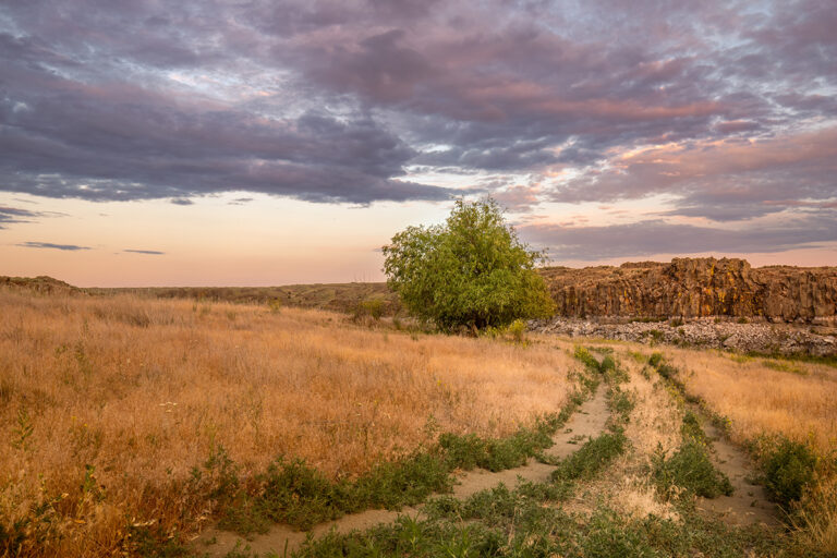
Family Fun Guide to Riverside Statw Park Juliet Sinisterra & Amy Silbernagel McCaffree MOST OF US KNOW IT SIMPLY as the “Bowl and Pitcher,” but Riverside State Park covers nearly 10,000 acres of land and 60 miles of trails. The Park offers an amazing array of outdoor activities for all ages throughout the entire year. Everything from mountain biking to camping, to canoeing and dogsled racing takes place in the Park. Summer, in particular is a great time to take the kids hiking in Deep Creek, attend evening events at the Park’s new outdoor amphitheater or relax and float down the Little Spokane River. The Park is a great place to simply enjoy the wildlife and quiet beauty of our own bioregion-and all just minutes from downtown. Annually, the Park is host to a variety of events: Spokane’s River Run, Winter Dog-Sled Racing, Round & Round’s 24-Hour Races and the Sunset XC Mountain Bike Race Series. During the school year, the Park leads educational tours to school groups and Park Rangers teach environmental conservation and the history of the Spokane area.
Park Manager, Rene Wiley, who loves to explore the Park year-round with her children, highly recommends the spring season as well. “May is a beautiful time. The trails are just gorgeous and the river is pristine. You can feel like you are totally alone in the wilderness. The songbirds are just fantastic.”
Founded in 1933, the Park was built through the gifts of a few individuals and Washington Water Power (Avista). President Franklin D. Roosevelt’s Civilian Conservation Corps built the roads into the area and the popular Swinging Bridge at the Bowl and Pitcher. Over the succeeding years the Park has gradually acquired more land through gifts and grants. Most recently, the Spokane County Conservation Futures program purchased land to protect a resource habitat area above the Little Spokane River. Currently the Park is working with Avista for a more formalized take-out next to the Nine Mile Ranger station. The Park is also trying to find another concession for horseback riding at the Trail Town Stables.
Following is a compilation of all the fantastic places to visit at Riverside State Park.
THE BOWL AND PITCHER: Named after the incredible rock formations that resemble its title, is the most popular area in the Park with over 2 million visitors annually. The Swinging Bridge carries pedestrians to the west side of the river where miles of trails and a small kitchen shelter can be found. Approaching the river from the east, picnic tables scattered alongside the river are a great place to relax and enjoy a meal before or after a hike. Park campgrounds are located further upstream, and a new outdoor amphitheater located near the campgrounds hosts Friday and Saturday evening events all summer (see side bar for information). The campgrounds are divided into a lower group of sites that sit closer to the river and an upper group about 100 yards from the river. Reserve early in the season, sites fill up fast. To reserve a campsite or the kitchen shelter call (888) 226-7688. Riverside State Park can accommodate 15 RV sites and 33 campsites total. Cost is $16 for a standard-tent and $22 for a RV hookup. You can also reserve single campsites on the internet at www.parks.wa.gov.
> HOW TO GET THERE: From Interstate 90, take the Maple Street Bridge exit, Exit 280. Go north across the Maple Street Bridge, and about one mile further north to the second signal light (Maxwell Street) after crossing the bridge. Turn left on Maxwell, and follow it as it winds westward and then northward. This road changes names twice, but within three miles you will come to the entrance of Riverside State Park. The Bowl and Pitcher is about two miles north of the park entrance along North Aubrey L.White Parkway.
DEEP CREEK CANYON & SEVEN MILE: For some of the most dramatic hikes in the Park look no further than the area around Deep Creek. “Deep Creek is just gorgeous. Eagle’s are a common sight during the winter months.You can hike up into Deep Creek Canyon and see old growth forest, lots of wildlife, and great views of the Spokane and the Little Spokane Valley,” says Park Manager Wiley. The best thing about Deep Creek, however, is the geology. Hiking the canyon, you are surrounded with basalt outcroppings up to 16 million years old. A picnic area is located near the parking lot. To the south and east of Deep Creek is Seven Mile. The Seven Mile area is host to a number of special events throughout the year. This area is loaded with mountain bike opportunities. Most rides originate on the west side of the Spokane River after crossing the Seven Mile Bridge. (Trailheads include turn-offs of Pine Bluff Road, Wilbur Road, Carlson Road and many others.) There are varying degrees of difficulty, and some trails are definitely not kid-friendly (unless they don’t mind having to hike-a-bike for certain portions). An excellent resource for detailed mountain bike trail information is Martin Potucek’s guidebook Mountain Biking Spokane and Coeur d’Alene, or the Spokane Outdoors web site, www.spokaneoutdoors. com. (Note: The 2nd edition of Potucek’s book was published in 2003. Since then a more detailed map of the trails within Riverside State Park has been created and can be purchased from the ranger office. The Trail map was created by Riverside State Park and the Back Country Horsemen. Trails are now numbered and wooden signposts were erected along trails.)
> HOW TO GET THERE: Take Francis heading west which then becomes Nine Mile Road (Hwy. 291) north from Spokane, at Seven Mile Road turn left. Just after you cross the Seven Mile Bridge, turn right onto Riverside Park Drive and continue until you come to the parking area overlooking the Spokane River. For Deep Creek, you will need to hike into the area of the Centennial Trail. After crossing a small bridge, you can walk into the canyon, take a trail just above the canyon or catch another trailhead further down along the Centennial Trail. You can also access Deep Creek from the Nine Mile area at the Carlson trailhead.
OFF ROAD VEHICLE (ORV) AREA: Riverside State Park’s ORV area is the only one in the State Park system. “We sacrificed these 500 acres to protect the remaining park,” says Park Manager,Wiley. The area offers hill climbs, sand areas and trails. However, keep in mind that there are no designated trails. Riders need an ORV tab for motorcycles or four-wheelers, or a licensed (off-road) vehicle. The ORV area is free to use and is open year-round. Restrooms, parking, two picnic shelters, a loading/ unloading ramp and a training area are also located at the site. > HOW TO GET THERE: Take Nine Mile Road (Hwy. 291) north from Spokane, turn left onto Seven Mile Road. Follow to Inland Road, take a left and follow to parking area.
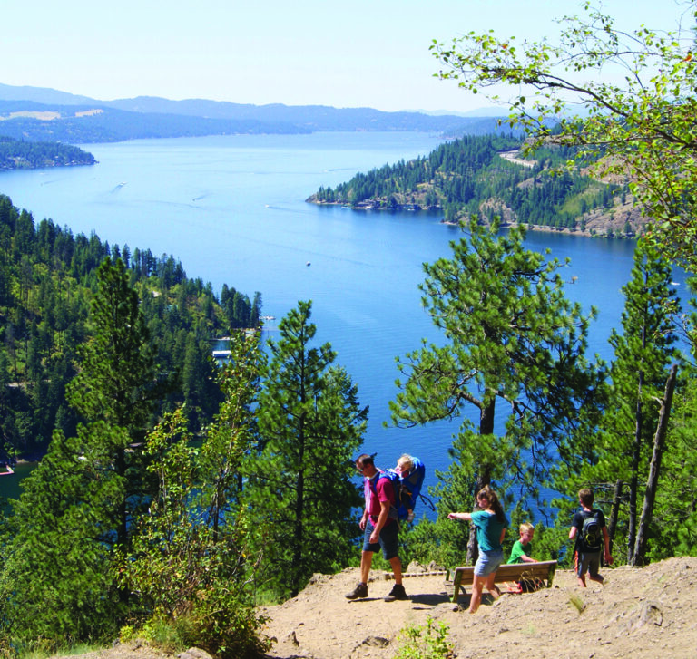
CENTENNIAL TRAIL: Riding through Riverside State Park along the Centennial Trail offers you with great views of the Spokane River and Valley and birds-eye views of the river including the Bowl and Pitcher. In contrast with the open terrain of the rest of the trail, this western portion has climbs and descents.
All 37 miles of the Centennial Trail are managed by Riverside State Park. The Trail is jointly maintained by Riverside State Park, the City of Spokane, Spokane Valley, and Spokane County. The Friends of the Centennial Trail is the community liaison for the Trail. Two Park Rangers patrol the Centennial Trail from Sontag Park to T.J.Meenach Bridge. Following are access points to the near around Riverside State Park:
- Military Cemetery (off Government Way at the 28-mile mark)
- Bowl and Pitcher overlook (30-mile mark)
- Seven Mile Road (34-mile mark)
- Sontag Park (37-mile mark)
- Foot travelers may also access the trail via the footbridge from the campground at Bowl & Pitcher, across the river from the trail.
- Maps of the trail are published by The Friends of the Centennial Trail and are available for a $3 donation at the Riverside State Park office.
LITTLE SPOKANE RIVER NATURAL AREA: This leave-no-trace sanctuary-and that includes swimming ripples-contains 7.3 miles of meandering river and nearly 2,000 acres of mostly freshwater marshes. The seeming isolation of this area makes it one of the easiest ways to escape the urban pulse of Spokane for total immersion in the outdoors. Although it’s best enjoyed while paddling a canoe or kayak down the river, there are also six miles of trails for exploring the diverse landscape which also includes pine forests and grass meadows.
The Nine Mile Ranger office provides canoe and kayak rental packages, which include the watercraft, paddles, personal flotation devices (PFD’s), and tie downs. Price is $25 for the first day, and $15 each day after that. Paddlers should check conditions before heading out and know how to navigate bushy banks and sharp turns. It is advised you stay in the middle of the river to enjoy the slow and steady current, but be aware of any changing river conditions. Throughout most of the lower stretches, the river is about 40-60 feet wide. The park foundation’s web site, offers a “Paddler’s Page” which provides information about current river conditions-including sweeper warnings-and upto- date information can be obtained through the ranger office by phone or through a personal visit. Guided tours of the river, for a fee, are also available. Solitude is the key word, as this section of Riverside State Park is more for appreciating the scenery and absorbing the beauty rather than for recreation. As a designated Natural Area, it’s considered a water trail. This means visitors are not allowed out of their self-propelled watercraft, and this includes hanging your feet or arms into the cool water. There is no swimming, floating on inner tubes or air mattresses allowed. Pets, bikes, camping, and exploring off the designated trails are also prohibited. Although rules are more stringent in this area, it’s for good reason, and humans who remain quiet, respectful, and observant can be rewarded with abundant bird watching opportunities and other wildlife sightings-including moose, even an occasional bear or cougar. “With development pushing in all around it, we want to keep it as natural as possible,” says Park Manager, Rene Wiley.
> HOW TO GET THERE: The three major parking lots near access points to the Natural Area, in downriver order, are: St.George’s – a parking lot and boat launch off of Waikiki Road near St. George’s School. Indian Painted Rocks – trailhead and parking lot off Rutter Parkway, half-way point for a float trip; can put-in or take-out here, however, there is a short walk to the parking lot (remember this before deciding to carry your canoe or kayak here: it’s “short” as in about 75 yards). Take-out site on the boat launch road off Highway 291, north of Nine Mile Falls.
INDIAN PAINTED ROCKS: In addition to a canoe/kayak put-in and/or take-out, the Little Spokane River Natural Area midway point includes a unique highlight: Two sets of ancient pictographs (rock paintings) on granite rock formations. Although no local tribes claim them, their creation is attributed to Native American inhabits of the Little Spokane River valley. The “paint” is actually a mixture of ochre, saliva, and animal grease or fish oil, and interpretations of what they depict include hunting, religious, or rites of passage. (Hint: A float trip can be broken up with a stopover here to explore the rocks and use the facilities before continuing downriver.)
> HOW TO GET THERE: From Francis, turn north onto Indian Trail Road, which eventually intersects with Rutter Parkway. Follow the curves; you will head down a hill along a rock wall and about 0.2 miles from the bottom of the hill will be the parking lot on your left. (Note: Rutter Parkway is undergoing construction this summer and is closed all the way from Highway 291 to Indian Trail Road.)
SPOKANE HOUSE INTERPRETIVE CENTER: This is the site of the first fur-trading post in what would eventually become Washington State. Originally built in 1810, the Spokane House was abandoned in 1826 for a better trading post location near the Columbia River. Today’s interpretive center was built near the original site, thanks to archaeological excavations in the 1950s and 60s that helped determine the location and layout of the destroyed building. Budget cuts now prevent rangers from staffing the center, but volunteers keep it open on the Saturdays from 10 AM to 4 PM. Call the ranger office to find out the exact times. (School groups still visit regularly in the spring.) In addition to touring the center, enjoy hiking the area trails and a picnic at any of the secluded river view tables. This would make for a great day trip with young children. > HOW TO GET THERE: From Highway 291, also called Nine Mile Road, go one half mile north of Charles Road (the Nine Mile Falls Dam bridge), and the entrance will be in the woods on the left.
NINE MILE & LAKE SPOKANE PROPERTY: Along Nine Mile Road (Highway 291) Avista’s dam and Nine Mile Falls are the main attractions. This is also where the Riverside State Park headquarters is located, across the bridge off West Charles Road. This main office offers an abundant supply of various brochures and guides to help you understand the park’s recreation options.
The Lake Spokane Property is a recently acquired property of 540 acres. It is located further downstream on Long Lake and, at the time, is undeveloped and being held for state park purposes. The area is becoming popular with Nine Mile residents and boaters. Boaters use the bay as a resting/picnic spot and enjoy the quiet wildlife and scenery. And, although the Park does not endorse it, the site has also become popular with mountain bikers, hikers and climbers wanting to cliff jump into lake. Cliff jumping is a dangerous sport and participants are responsible for their own safety.
There are no restrooms currently available, and alcohol and campfires are prohibited. The Park is working towards providing facilities for day users, such as restrooms.
> HOW TO GET TO THE LAKE SPOKANE PROPERTY: Heading north on Nine Mile Road (Hwy 291), you go through the town of Nine Mile Falls; take a left across dam (Charles Road). Go about 7 miles to South Bank Road, take a right there. Stay on South Bank Road until the pavement ends. Follow dirt road for about 1 1/2 miles. You will see a park boundary & rules sign. Keep right. Park in parking lot. Walk down road to day use area.
The Riverside State Park Foundation includes committees responsible for fundraising, membership, resource preservation and building and maintaining the trail system. Individual or Family General Membership is either $10/year or 10 hours of documented volunteer service. Supporting Membership is $50/year. For more information please visit www.riversidestatepark.org/foundation.htm.
For more information please visit www.riversidestatepark.org/foundation.htm.
For more detailed Park information visit www.parks.wa.gov or www.riversidestatepark.org. or call (509) 465-5065.