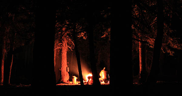
While Memorial Day to Labor Day may be prime time for backpacking, it’s not absolutely necessary to pack away the tent until warmer weather returns. With a trailhead that is generally accessible into the colder months and a bridge over the trickiest water crossing, the Panjab Trail into the heart of the Wenaha-Tucannon Wilderness can be a good trail for a winter backpacking excursion, whether it be for nocturnal stargazing, marking the winter solstice and the promise of longer days ahead, or a recharging during the busy holiday season.
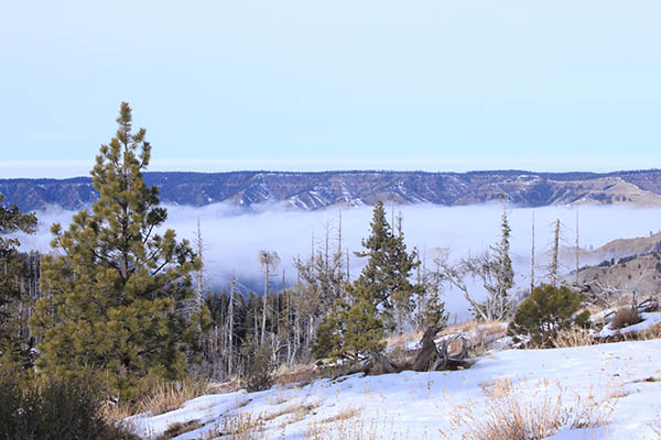
When I did this trip in December 2017, Spokane was in the grips of a temperature inversion that had us suffering through our short winter days in a thick fog the sun couldn’t penetrate. It’s the type of weather I find positively oppressive. Meanwhile, weather reports were indicating a chance to get above the clouds to experience warmer daytime temperatures in the southeast corner of the state. It just so happened that it all coincided with the Geminid meteor shower, which will peak the night of December 13 through the following morning this year.
Begin this hike by crossing a footbridge over a rushing creek and immediately entering the Wenaha-Tucannon Wilderness. Bear left and continue uphill at an unmarked intersection with the Turkey Creek Trail at approximately the one-mile mark. The Panjab trail climbs 2,500 feet in nearly 5 miles to the first good campsite at Dusty Camp, just below Indian Corral and the Mount Misery trail. Set up camp here, or else continue to Indian Corral and camp at the nearby Dunlap Springs. Both locations have access to water in the event there isn’t enough snow on the ground to melt for drinking and cooking. After base camp is set up, the high country along the Mount Misery trail offers several options for exploration. Follow Mount Misery south toward Oregon Butte or east toward Diamond Peak. From the Indian Corral junction, the upper portions of the Rattlesnake Trail follow the ridge north to a vantage point overlooking the Tucannon River drainage. Competition for campsites shouldn’t be intense during the winter months, but know that additional campsites are located along all of these trails.
When planning a December backpacking trip, fickle weather will always be a cause for concern. The Panjab trailhead was accessible in December last year, but this year’s conditions could be different. The Tucannon River Road is plowed to the end of the pavement, which is a little over two miles from the Panjab trailhead. It’s also possible to access the Rattlesnake Trail from the Panjab campground at the end of maintained road. The main difficulty with this option is that there is no footbridge over the creek at this location. Sometimes a fallen log can be used to cross, or hikers can wade across. It makes for a cold start to a December trip, but is a good alternative in case snow prevents access to the upper trailhead.
Snowshoes may be necessary in the higher sections of the trail, and the lower portion of the trail could have icy sections that would require either snowshoes or microspikes. A good way to assess possible snow depth in the high country is to check the closest SnoTel site at Spruce Springs, or to check the snow data for nearby Bluewood Ski Area. Please remember that blue bags/wag bags are necessary for winter camping trips, since the ground will likely be frozen or covered in snow.
Prefer to day hike this trip and stay in a nearby historic cabin? See the “Four Winter Cabin Trips” article in the February 2018 issue of Out There online for a description of the nearby Tucannon Guard Station, which is available for year-round rental through Recreation.gov.
Round-trip Distance: 10 miles round trip and 2,500 feet elevation gain, with options for additional hikes from camp.
Rating: Moderate to difficult
Maps:
U.S. Forest Service map: Umatilla National Forest, Pomeroy Ranger District including the Wenaha-Tucannon Wilderness, 2013
USGS maps: Panjab Creek
Getting There: From Spokane, take US 195 south to Colfax. Travel west on WA 26 for 16.6 miles to Dusty, then travel south on WA 127 for 27 miles to the junction with US 12. Travel east on US 12 for 8 miles to Tatman Mountain Road. Continue on Tatman Mountain Road to Linville Gulch, then Blind Grade Road. At the intersection with the Tucannon River Road, turn left and follow the Tucannon River upsteam to Forest Service Road 47. When the pavement ends at FS 4713, bear right and continue 2.4 miles to the Panjab trailhead. Northwest Forest Pass required. //
Holly Weiler is the eastern region coordinator for Washington Trails Association. She writes the Hike of the Month column in every issue of Out There.