Backcountry roads can be the necessary evil of adventure: every recreationist has his or her story of harrowing, white-knuckled mountain driving or late-night tire repair far from the nearest Les Schwab. But sometimes it’s ok to embrace the backcountry drive, not as a means of getting to the destination but as the destination itself. On these seven scenic backcountry byways, the answer to “Are we there yet?” is always “yes.”
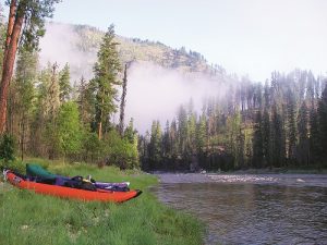
Selway River (North Central Idaho)
Part of the original Wild and Scenic Rivers Act, the Selway River in North Central Idaho rumbles out of the heart of the 1.3-million-acre Selway-Bitterroot Wilderness that, together with the adjacent Frank Church – River of No Return Wilderness, spans a primeval area the size of Delaware. The upper Selway’s legendary whitewater and pristine beaches host once-in-a-lifetime float trips and long multi-day backpacks, but the 21-mile drive on the Selway River Road from Lowell, Idaho – between Missoula and Lewiston on U.S. Route 12 – to its terminus at Selway Falls is accessible to anyone (and should be required driving for adventurous Inland Northwest residents).
Along the way – paved the first 5 miles and then washboarded gravel beyond – the road parallels sand beaches and sculpted boulders, with the steep, fir-cloaked canyon increasing the feeling of solitude. Nearly halfway in, the historic Fenn Ranger Station is worth a stop; across the road, Fenn Pond, with an accessible trail and boardwalk, offers kid-friendly fishing with stocked and catchable fish. Daytrippers can enjoy the Selway from several sandbars with undeveloped beaches for swimming and picnicking.
Campers can choose among sites in 13 campgrounds; Race Creek Campground at the Selway River Trail terminus makes a fine staging point for day and overnight trips into the wilderness. The 12-mile roundtrip hike to Cupboard Creek rapids rates as a good turnaround spot for a long day hike or overnighter, although groups with young hikers may choose to stop at any of the beaches before then. Herpetophobes beware: the Selway’s rattlesnakes are legendary and legion.
Northwest Peaks Scenic Area (Northwest Montana)
Tucked in the thick mid-elevation forests of far Northwest Montana, the tiny community of Yaak is not on the way to anything. And the nearby Northwest Peaks Scenic Area is out of the way even for Yaak residents. That alone recommends it for a wild drive, but the scenery helps too – a lonely country of thick forests, glacier-ground peaks and tiny lakes, a quiet neighbor to the Selkirks and Cabinets to the west.
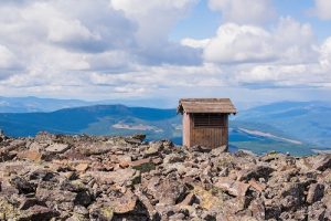
At 7,706 feet, Northwest Peak is the centerpiece of the 19,000-acre Northwest Peaks Scenic Area, its summit easily accessible via a long drive and short hike. The 22-mile drive on Pete Creek Road to the Northwest Peak trailhead winds past graceful aspens and willow-dense meadows; no wonder this is grizzly and moose country. Just before the trailhead to Northwest Peak, a viewpoint peers over the frequently fog-shrouded Yaak Valley.
Save for the last quarter mile of talus, the 5-mile roundtrip trek to the summit makes for one of the easiest alpine summit hikes in Northwest Montana. From the white clapboard walls of the old fire lookout, hikers are likely to have the summit view all to themselves, and there’s never a line for the outhouse (one of Montana’s highest-elevation privies). The alpine larch – relatively uncommon to the Inland Northwest – make this a great fall hiking destination. Just make sure to plan for every possible type of weather; even in the meteorologically fickle state of Montana, the northwest corner has notoriously capricious conditions.
Just up Pete Creek Road from the Northwest Peak trailhead, a quarter-mile trail accesses the Hawkins Lakes; anglers can land successful casts from the granite hunks surrounding the shore. Aside from the Yaak River Tavern and Mercantile on one side of the two-lane highway and the Dirty Shame Saloon on the other, nearby Yaak doesn’t offer much in the way of services, but the beer and bar-stool philosophizing are both abundant.
Salmo Lookout (Northeast Washington)
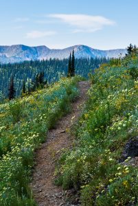
Although the Shedroof Divide, the north-south ridge that straddles the Idaho-Washington border and separates the Pend Oreille and Priest River drainages, lies within the Selkirks, it bears little resemblance to the Selkirk Crest east of Priest Lake; think beargrass-clad balds rather than cliff-hanging alpine lakes. But the open terrain makes for stunning views – shared only with mule deer, black bears and moose (and a handful of grizzlies and caribou). Although backpackers can string together a variety of multi-day scenic loops, a 19-mile drive on surprisingly good gravel roads from the Sullivan Lake Ranger Station nets one of the best views, at 6474-foot Salmo Mountain.
From the extant fire lookout, gaze into the green heart of the 41,000-acre Salmo-Priest Wilderness. To the west tilts the distinctively off-kilter pyramid of Hooknose Mountain; the spires of the southern British Columbia Selkirks stand to the north; far below to the east lies Priest Lake. Nearby, the 19-mile Salmo Loop trail descends to the cedar-shaded Salmo River and back up through brushy, bear-friendly meadows before reaching the Shedroof Divide, where snags from past fires frame non-stop views on the latter half of the loop. Plan extra time for harvesting the copious huckleberries – all the more plentiful for being so hard to reach.
Halfway up Forest Road 22/2220 from Sullivan Lake to Salmo Mountain, car campers will find good, primitive tent sites in Gypsy Meadows, which is popular with backcountry horsemen. On your way back out of the mountains, take a dip in the sun-warmed waters of Sullivan Lake, northeast Washington’s largest naturally-formed lake.
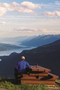
Buchanan Lookout (West Kootenays, B.C.)
Miners and millionaires once packed the narrow boomtown streets of southern British Columbia’s Silvery Slocan Valley. Today, the area formerly known as the “Monte Carlo of North America” hides recreational riches in its rugged peaks. But with few exceptions, the peaks are the province of backpackers after arduous hauls through dripping cedar forests and brush-choked avalanche slopes. So it’s all the more remarkable that drivers can step out of their vehicles at the foot of a fire lookout and enjoy such wild scenery so close to the plentiful tourist amenities in the nearby village of Kaslo, an hour north of Nelson on Kootenay Lake.
Not that the drive is easy: the rutted, moderately exposed road, with steep, straight grades exceeding 20%, will have drivers’ eyes glued to the gravel; passengers will marvel that full log trucks screech down this insane pitch. Plan for the 8-mile drive to take about 45 minutes. But the view from the summit is worth any amount of driver distress. At 6,373 feet in height, Mount Buchanan is a baby compared to its neighbors, but that just means distant peaks feel all the bigger.
The recently restored lookout is locked, but visitors can peer in the windows at a fully furnished diorama representing lookout life in the 1950s and 1960s, complete with self-guided interpretive signs. Picnickers will find two tables and a privy. A 1-mile trail encircles the summit, perfect for post-picnic strolling; a paragliding ramp and a gnarly, white-knuckle mountain bike trail invite less-sedate pursuits. In each of the cardinal directions, signs denote the seemingly endless array of peaks in the Monashees, Selkirks and Purcells: 9,117-foot Mount Loki rising a mile and a half above the east shore of Kootenay Lake; 8,504-foot Mount Brennan piercing the heart of the Goat Range to the northwest. And, near at hand, a riot of wildflowers: glacier lilies, lupine, lovage and more. This is, quite possibly, the best drive-to view in the region. Just make sure your brakes are up for the drive back down.
Heart of the Bitterroots (North Central Idaho/Northwest Montana)
The southern Bitterroot Mountains tend to grab all the glory with their chasm-like canyons and cloud-catching crags. But the northern reaches of the Bitterroots – the area bounded roughly by Lolo and Lookout Passes – offer their own quietly rugged charm. Dozens of lakes dot the landscape, many of them accessed via anyone-can-do-it trails. Although for the most part below treeline, the ridges boast expansive vistas, thanks the catastrophic wildfires of the 1910 “Great Burn,” which left a patchwork of forested and flower-clad ridges.
Of several long backroad drives that are possible in this vast, wild region, the Cedar Creek Road out of Superior, Montana, offers perhaps the easiest lake access. From I-90 at Superior, it’s 25 miles of newly graded gravel to the Idaho/Montana state line on the Bitterroot Divide. Just below the divide, Missoula Lake Campground offers a handful of primitive sites among the trees; anglers can fish for feisty cutthroats from the brush-lined lake, a half-mile hike from the campground. The campground also makes for a pleasant base for day hikes on the Stateline Trail, which traces the ridgeline through dry lodgepole forest, stunted subalpine groves and grassy meadows.
From the pass where Cedar Creek bisects the trail, hikers might make for sawtooth-sided Illinois Peak to the south (8 miles roundtrip) or the stunningly scenic pair of Bonanza Lakes to the north (5.5 miles roundtrip). For a top-notch, albeit rough drive, continue into Idaho high above the headwaters of the world-class angling waters of the St. Joe River. Deeper into Idaho, the road gets progressively worse; plan two hours to drive the 20 or so miles from the state line to the historic Red Ives Cabin and miles of riverside hiking along the St. Joe.
Vermillion River (Northwest Montana)
Adjacent to the southernmost reaches of western Montana’s Cabinet Mountains Wilderness lies a little-known and lightly explored region of rugged ridgelines, expansive wildflower meadows and steep, glacier-gouged basins. Draining over 75,000 acres of brushy, arid hills, the Vermilion River was the site of early mining, and its name may refer to the red-colored rock in the canyons; now it could just as easily refer to the reddish berries that grow in the open forests along the drainage, the picking of which is a far more fruitful pursuit than the silver and gold operations ever were – the open lodgepole forests of the Vermilion River drainage are ideal huckleberry hunting grounds.
Even amongst locals, the dusty and potholed Vermilion River Road has a rough reputation. But summer weekends see a steady trickle of traffic: local wood-cutters laying in a winter supply of larch, huckleberry pickers filling their buckets. From the road, miles of short, interconnected trails allow for trips tailored to a variety of skill and fitness levels. One must-visit hike is the hundred-yard trail from the Vermilion River Road to the bedrock banks of Vermilion Falls. Huckleberry shrubs crowd the cascades, a shady picnic spot complete with berry snacks.
Campers can find quiet tent sites at Willow Creek, 13 miles up the Vermilion River Road. A few miles beyond are a handful of dispersed sites at pretty, tree-ringed Sylvan Lake, silent even on peak summer weekends. Nearby, in the Clark Fork River Valley, is the tiny town of Trout Creek, designated by the Montana legislature as the state’s huckleberry capital – no mean feat in a state where the purple berry has been elevated to royalty. Travelers who have not had their fill of huckleberries can find it here in any permutation possible: honey, soap, lip gloss and liquor.
Elk River Backcountry Byway (North Central Idaho)
Drive the 57-mile Elk River Backcountry Byway in North Central Idaho and experience the state in miniature. Where the Palouse meets the western outposts of the Rocky Mountains, monuments to logging history stand side by side with the state’s largest tree, and the state’s tallest waterfall plunges not far from the third-tallest dam in the United States.
Short stretches of paved two-lane highway bracket a slow-going gravel road. From Orofino, on the Clearwater River, the Elk River Backcountry Byway passes massive Dworshak Reservoir before crossing Dent Bridge – described, shortly after it was constructed, as one of the most beautiful structures in America. A potholed forest road climbs high above Dworshak Reservoir to the community of Elk River. Initially settled as a recreation destination for Inland Northwest residents at the turn of the 20th Century, Elk Creek Reservoir embraced timber before coming back to its recreation roots. The reservoir, originally created by Potlatch Timber as a holding pond for logs to be shunted down to the Clearwater, now holds hungry fish under its pine-shaded waters.
Seven campgrounds scattered around Elk Creek Reservoir offer fir-shaded sites. The kid-friendly 3.5-mile hike to Elk Creek Falls takes in three closely-linked cascades that, altogether, plunge 140 feet – the tallest such falls in Idaho. From the town of Elk River, the winding two-lane road passes the low forests and rolling hills of the Palouse fringes before entering the tiny town of Bovill and then Moscow. No-frills natural beauty and testaments to human hard work: this is quintessential Idaho. //